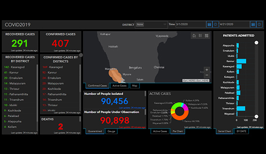
A staggering wealth of geospatial information has emerged
regarding the COVID-19 outbreak. Dashboards, near real-time
services, and GitHub repositories have built the foundation for an
extraordinarily transparent response effort. At this point, most
cases of COVID-19 are outside of the United States, so most
information products are at a global scale. As cases begin to
surface domestically, your GIS division might be asking:
“How can we apply this information to prepare locally?”
Figure out what you are trying to do, leverage the
information already available, then acquire what is missing.
It is incredibly easy to jump directly into building dashboards and start adding layers, maps, indicators, and bar charts. While this might result in a “one-stop-shop” for important information, remember that GIS can be leveraged in other powerful ways if the right questions are asked. Some examples that might guide the process are:
Do we have schools in socially vulnerable areas?
Which neighborhoods are distant from a COVID-19 testing clinic?
Do we have communities at a greater risk?
Which facilities and staff are in harm’s way?
Like with dashboards, answering these questions results in highly actionable information. They can dictate which schools need enhanced monitoring, which neighborhoods need access to a mobile testing clinic, where to target outreach and how to modify operations. These answers tell us where to deploy resources and, equally important, where not to waste resources. It also tells us what ingredients we need to start looking for.
Fortunately, GIS has made the process even easier, and released the Coronavirus Response Solution. Deploying the solution results in a collection of maps and apps that can be used by Public Health agencies to understand the impact of the coronavirus (COVID-19) and share authoritative information about the pandemic with your community.
It includes the following tools :
Geographic Information Systems can be the tool that helps local communities regain control of this crisis, because location is the common denominator between every department. GIS teams across the country should be front and center as coordinators for pandemic preparedness and response. Taking a chef’s approach to GIS ensures you are strategic and successful in this endeavor.
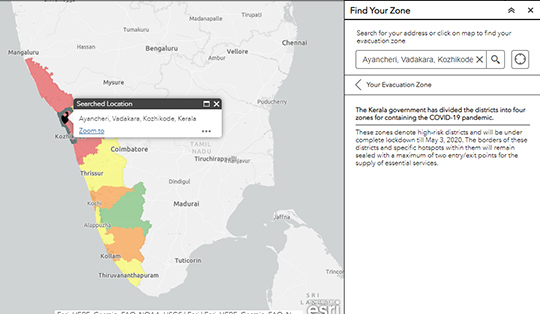
Helps to identify the zone to which a place belongs to. (Red, Orange or Green) and respective rules and regulation
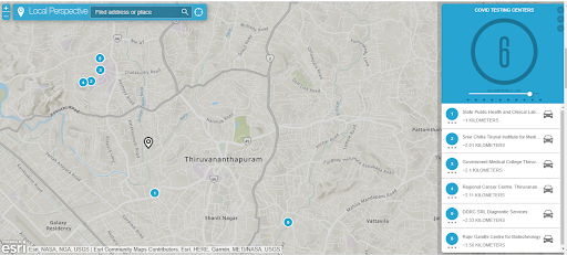
Showcases the Medical Stores, Hospitals, testing centers, Community Kitchens, etc near a location